
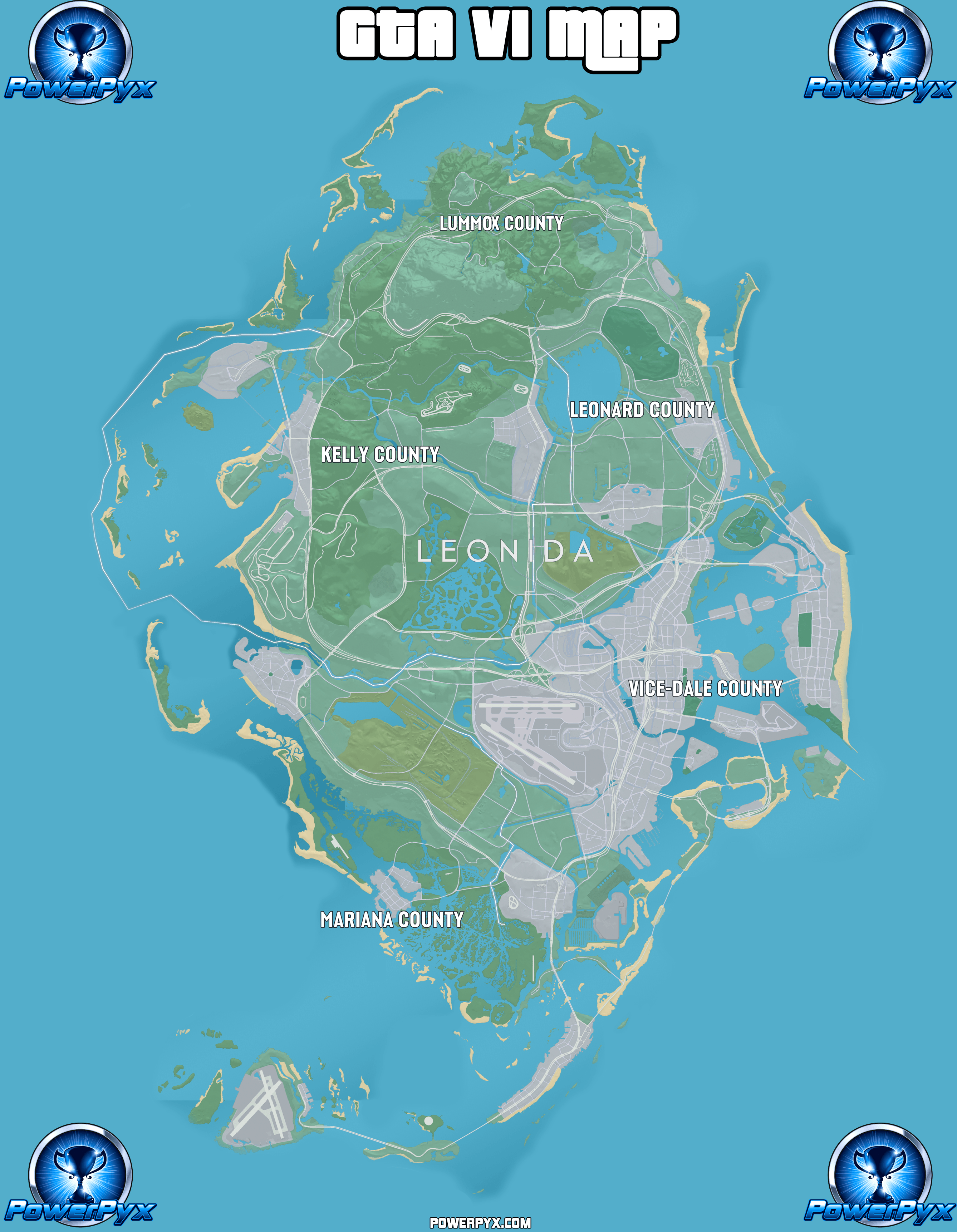
GTA 6 (Grand Theft Auto VI) has a huge World Map. This page reveals the full in-game map in high resolution.
There are 5 Districts on the Map of Leonida: Mariana County, Vice-Dale County, Kelly County, Leonard County, Lummox County.
The total map size of GTA VI is 175km² (16km height x 10.9km width) / 67.5 square miles (10 miles height x 6.75 miles width).
The map consists of roughly 35% water and 65% landmass. You can also go inside many of the buildings (but not all of them) and explore multiple floors in some skyscrapers by taking the elevator.
Below you can find the full GTA VI World Map (In-Game Map):
List of Regions & Sub-Regions (Named Locations)
Mariana County (Southern Region)
- Mile Zero Air Station
- Southwind
- Riquezas Keys
- Permit Keys
- Maroon Key
- Abismo Key
- Leonida Bay
- Key Lento
- Gambit Bay
- Shoeless Keys
- Corsair Key
- Peregrine Bay
- Leonida Straits
- Pelican Valley (Swamps)
- Cottomouth Lake
- Wetman Bay
- Gullet Marsh
- Pelican River
- Watson Bay
- Bobcat Key
- Bobcat Bight
- Grassrivers
- Tola Bay
- Capri
- Tortoise Lake
- Capri Sound
- Belpoint
- Gulf of Leonida
- North Mariana County
- Nehrling River
Vice-Dale County (Main City)
- Hamlet
- South Vice-Dale County
- VCIA
- Vice City
- Southside
- Peacock Bay
- Tequesta
- Tequesta Retreat
- Downtown
- Little Cuba
- Salton
- Rockridge
- Crosstown
- Bayside
- La Perle
- Balsero
- Stockyard
- Decor District
- Leaf Links
- Rialto Islands
- Starfish Island
- Waxman Island
- Port Vice City
- Catalan Bay
- Catalan Key
- Gloriana Key
- Dalton Island
- West Vice-Dale County
- Vice Beach
- Ocean Beach
- Washington Beach
- Atlantic Ocean
Kelly County (North-West Region)
- South Kelly County
- Buckskin Swamp
- Emerald River
- Emerland Springs
- Gellhorn
- Port Gellhorn
- Wild Hog Point
- Borrachero Sound
- Crude Islands
- Sandbars
- Draper Island
- Draper Bay
- North Kelly County
- Frogswater
- Manifest Canyon
Leonard County (North-East Region)
- South Leonard County
- Belville
- Waning Sands
- Leith River
- North Leonard County
- Lake Leonida
- Richard Barebone State Park
- Little Hardin Island
Lummox County (Northern Region)
- South West Lummox County
- Zephyr Islands
- Mount Kalaga National Park
- Grayson
- San Malo Bay
- Featherstone Islands
- Bonanza
- Okchioha Bay
- Moreau
- MacAlister Gold Mine
- Saint Attaway Islands
- Hyde Island
- Moreau River
- East Lummox County
- Partridge Bay
- Frampton Islands
- Lake Tallaloko
- Kalaga Reservoir
- Dawson Dam
- Millport
- Millport Basin
Map Icons & Locations
 39 Gang Operations (Illegal Operations)
 22 Bank Jobs (14 Small Banks, 8 Large Banks / Bank Vaults)
 7 Payday Loans
 35 Smash ‘n’ Grabs
 14 Mod Shops
 19 Pay ‘n’ Sprays
 57 Gas Stations
 6 Car Washes
 24 Ammu-Nations (Gun Stores)
 12 Garages
 25 Train Stations
 2 Ferry Terminals
 67 Clothing Stores
 17 Footwear Stores
 18 Hair & Beauty Salons
 11 Tattoo Studios
 15 Electronics Stores
 72 Convenience Stores
 21 Fast Food Stores
 87 Cafes & Takeout
 14 Liquor Stores
 122 Bars
 118 Street Food Vendors
Leave a Reply